The Historical Journal
FEBRUARY 2026|VOLUME 69|ISSUE 1
《历史期刊》
2026年2月|第69卷|第1期
英国对香港滨海空间与船艇的殖民统治,1841—1898年
British Colonial Rule over Littoral Space and Watercraft in Hong Kong, 1841–1898
GARY CHI-HUNG LUK
英国在香港的统治延伸到了海岸之外。在第一次鸦片战争(1839—42)期间,英军侵华远征队攻占了位于中国南方珠江三角洲的香港岛,并于1841年1月宣布控制其港湾。二十年后,中国大陆上的九龙半岛、其毗邻水域以及昂船洲在第二次鸦片战争(1856—60)后成为香港的一部分。1879年,一项地方条例将“殖民地水域”界定为“位于距海岸一海上里格[即三海里]半径之内的水域”,但不包括“位于中国帝国领土界限或管辖范围之内”的水域。
British rule in Hong Kong extended beyond the shore. During the First Opium War (1839–42), the British expedition to China conquered Hong Kong Island, in South China’s Pearl River Delta, and proclaimed control over its harbours in January 1841. Two decades later, Kowloon Peninsula on the Chinese mainland, its adjoining waters, and Stonecutters Island became part of Hong Kong after the Second Opium War (1856–60). In 1879, a local ordinance defined the ‘Waters of the Colony’ as ‘the waters situate within a radius of one marine league [i.e. three nautical miles] from the shores’ except those ‘within the territorial limits or jurisdiction of the empire of China’.
本文聚焦于1841年至1898年间英国对香港海岸、水域与岛屿的统治,这一时段自其殖民时期伊始,至改变殖民地海洋景观的新界租借前夕为止。本文主张,与其对城市空间的统治相似且彼此关联,19世纪香港的英国政府致力于划分并规制殖民地的水域边缘地带。然而,这类官方努力并未使海岸、水域与岛屿按计划被使用。利益相关者不仅围绕其使用展开竞争与协商,而且许多中国船只还通过跨越英属香港与清中国的边界,来对抗官方控制。
This article centres on British rule over the shores, waters, and isles in Hong Kong between 1841 and 1898, from the beginning of its colonial period to the eve of the lease of the New Territories that transformed the colony’s maritime landscape. It argues that similar and connected to its rule over urban space, the British government of nineteenth-century Hong Kong endeavoured to divide and regulate the colony’s watery fringes. Such official efforts, however, did not result in the use of the shores, waters, and isles as planned. Not only did stakeholders compete and negotiate over using them, but also, many Chinese watercraft countered official control by venturing across the boundaries of British Hong Kong and Qing China.
更广泛而言,香港这一案例展示了亚洲殖民港口城市滨海地带的双重历史:殖民当局如何将本地滨海空间纳入控制,以及其他各方——无论本地还是外来——如何围绕其使用与之协商、抗争。1841—98年间,英国规章取代了香港地区——包括其岛屿与水域——原有的清朝规制。当然,香港水域空间上的许多官方措施并不限于殖民属地,而是适用于全球各港口。这些措施之所以具有殖民性质,是因为它们既符合英国治理香港的利益,也源于英国当局如何看待其人民与船只——无论中国人与非中国人皆然。尽管如此,英国殖民控制在很大程度上未能将中国人的海上活动限制在更为庞大的华南水上世界之内;在这一世界中,国家力量——无论清朝还是英国——往往都相当薄弱。
More broadly, the case of Hong Kong illustrates the twofold history of the littorals of colonial port cities in Asia: how colonial authorities brought native littoral space under control and how other parties – native and non-native alike – negotiated and contested with them over its use. In 1841–98, British regulations replaced the Qing ones in the Hong Kong region including its isles and waters. Certainly, many official measures on Hong Kong’s watery space were not limited to colonial possessions but were applicable to ports across the globe. These measures were colonial because they aligned with British interests in governing Hong Kong and stemmed from how the British authorities saw its people and ships, Chinese and non-Chinese alike. Nonetheless, British colonial control largely failed to limit Chinese maritime activities within the much larger waterworld of South China where state presence – either Qing or British – was often tenuous.
呼应殖民叙事,关于香港港口发展的研究通常接受英国政府在这一转口港经济成功中所扮演的积极“不干预”角色。这掩盖了英国对香港水域边缘地带统治所面临的挑战。关于19世纪香港的一些研究,已部分处理这些挑战。克里斯托弗·芒恩考察了中国“船居社群”的迁徙如何给英国殖民治理带来问题,而卡罗尔·曾则解释了殖民当局如何将中国“水上世界”视为一个充斥性病、海盗及其他犯罪的空间。两者都强调英国统治者无法渗透进中国人的“浮动世界”。这一点固然属实,但这种强调却遮蔽了官方自1841年以来——尤其是在1860年九龙割让、英国开始控制维多利亚港两岸之后——持续努力维持殖民地水域秩序这一事实。
Echoing the colonial narrative, scholarship on the port development of Hong Kong has generally accepted the positive non-interventionist roles of the British government in the entrepôt’s economic success. This obscures challenges to British rule over Hong Kong’s watery fringes. Some scholarship on nineteenth-century Hong Kong has partially addressed these challenges. Christopher Munn has examined the problems of British colonial governance caused by the migratory Chinese ‘boat-dwelling communities’, and Carol Tsang has explained the colonial perceptions of the Chinese ‘waterworld’ as one beset with venereal disease, piracy, and other crimes. Both stress the British rulers’ inability to penetrate into the Chinese ‘floating world’. While true, this emphasis veils the persistence of official efforts to keep the colony’s waters in order from 1841 – particularly after the cession of Kowloon and the beginning of British control over both shores of Victoria Harbour in 1860.
为填补这一空白,本文提出将“滨海地带”作为香港历史研究的一个课题。使用这一概念,能够将对其殖民关系的关注点从定居聚落转向船只。此外,它还有助于将英属香港与其他以水发挥界定性作用的殖民港口城市联系起来。迈克尔·皮尔逊将“滨海地带”界定为“沿海海域、海滩,以及陆地上某种不确定的边界地带”,这一地带既区别于内陆地区与深海,又与之不可分离。一般而言,1841—98年间不断演变的香港滨海空间包括维多利亚港及其岛屿;沿殖民城市维多利亚城与(自1861年起的)九龙半岛一侧、点缀着码头、栈桥与海滩的港湾边缘;以及维多利亚港之外、处于殖民管辖下的海岸、水域与小岛。在这一滨海空间中,维多利亚港是殖民地与世界之间海上联系的枢纽,因此也是英国控制的核心场域。
Filling this lacuna, this article proposes ‘the littoral’ as a subject of historical enquiry of Hong Kong. Use of this concept shifts focus on its colonial relationship from the sedentary settlement to the watercraft. Moreover, it helps connect British Hong Kong with other colonial port cities where water plays a defining function. Michael Pearson defines ‘the littoral’ as ‘the coastal sea zone, the beach, and some indeterminate frontier on land’ distinct yet inseparable from the inland regions and deep water. Generally speaking, the evolving littoral space of Hong Kong in 1841–98 comprises Victoria Harbour and its isles; the harbour’s edges along the colonial city of Victoria and (from 1861) Kowloon Peninsula dotted with wharves, piers, and beaches; and the shores, waters, and islets beyond Victoria Harbour under colonial jurisdiction. In this littoral space, Victoria Harbour was the pivot of the colony’s maritime connections with the world and thus a locus of British control.
在殖民地香港,英国对城市空间的统治与对滨海空间的统治既可比拟,也彼此相关。学者们已经说明,在第二次世界大战前,英国当局如何通过居住隔离、妓院规制及城市规划的其他方面,规划并划分殖民地的陆地空间。与亚洲其他殖民城市一样,种族在香港城市空间政策中发挥了重要作用。其他因素还包括地理环境、阶级与经济考量、健康与疾病、建筑风格与社会习俗、技术发展以及军事。其中一些因素为种族隔离、等级与歧视提供了正当化理由,掩饰了它们,甚至强化了它们。
In colonial Hong Kong, British rule over urban space and British rule over littoral space were comparable and connected. Scholars have illustrated how British authorities planned and divided the colony’s land space before the Second World War with residential segregation, brothel regulations, and other aspects of urban planning. As in other colonial cities in Asia, race played important roles in Hong Kong’s urban spatial policies. Other factors included geographical settings; class and economic considerations; health and disease; architectural style and social customs; technological developments; and the military. Some of these factors justified, disguised, and even reinforced racial segregation, hierarchy, and discrimination.
与城市空间的情形相似,上述因素推动香港殖民当局为不同船只的使用而划定维多利亚港及其他滨海边缘地带。随着航运增长,英国通过航标、浮标与系泊设施对维多利亚港进行划界——这些都是政府控制在海上的标识——并变得日益繁复。这使特定港湾空间变成了陆地空间的镜像,甚至是其延伸。此外,到19世纪后期,滨海空间内部一种正在形成的等级秩序已可辨认。这种空间分化反映了官方对香港水域边缘地带的二分态度。政府一方面将“核心”港湾空间与其相邻的已开发陆地区域整合起来,另一方面又把周边岛屿与水域隔离出来,使之成为容纳“不受欢迎”因素的孤立空间。
Similar to the case of the urban space, the factors listed above propelled colonial authorities in Hong Kong to delimit Victoria Harbour and other littoral fringes for the use of different watercraft. Commensurate with the growth of shipping, the British demarcation of Victoria Harbour by beacons, buoys, and moorings – offshore signs of government control – became increasingly elaborate. This transformed particular harbour spaces into mirrors or even extensions of land spaces. Moreover, by the late nineteenth century, an emerging hierarchy of the littoral spaces was discernible. This spatial differentiation reflects bifurcated official attitudes towards the watery fringes of Hong Kong. While the government integrated ‘prime’ harbour spaces with their adjacent developed land areas, it segregated peripheral isles and waters that served as isolated spaces for ‘unwanted’ elements.
尽管英国殖民当局努力规制并组织滨海空间,但在19世纪香港,他们未能主导其实际使用方式。正如前人研究所示,香港是众多殖民城市之一,在这些城市中,地方实践常常削弱城市规划。类似地,英属香港的滨海空间也是一个“社会冲突的场域”。中国与非中国的船只和人员频繁争夺繁忙的维多利亚港及其岛屿的使用,公然违逆行政上对港湾空间的划界。此外,殖民当局缺乏足够力量,去监督并编册统计那些被要求停留在指定锚泊区的中国船只。更重要的是,许多中国船只的跨境活动,如海盗与走私,超越了行政边界。就滨海地带与外海在流动的华南海洋世界中的连通性而言,英属香港政府在试图将滨海空间纳入殖民疆域时,遭遇了巨大挑战。
Despite their efforts to regulate and structure the littoral space, British colonial authorities failed to direct its actual usage in nineteenth-century Hong Kong. As shown by previous scholars, Hong Kong was one of the many colonial cities where local practices often compromised urban planning. Similarly, the littoral space of British Hong Kong was ‘an arena of social conflict’. Defying administrative demarcation of the harbour space, Chinese and non-Chinese craft and persons frequently competed over using the busy Victoria Harbour and its isles. Also, colonial authorities lacked sufficient power to supervise and enumerate the Chinese watercraft required to remain in designated anchorage areas. More importantly, the transborder ventures of many Chinese watercraft such as piracy and smuggling transcended administrative boundaries. In terms of the connectedness between the littoral and the open sea within the fluid maritime world of South China, the British Hong Kong government encountered immense challenges when attempting to incorporate the littoral space into the colonial realm.
从更宽广的历史视野来看,与英属香港相似的对滨海空间的官方控制,也发生于近代中国的条约港——如上海——以及亚洲其他殖民港口城市,如新加坡、孟买与加尔各答。关于这一主题的现有讨论,多聚焦于填海与港口设施,将其视为港口城市繁荣与“现代化”的一部分。尽管不同地方历史语境中的滨海地带各不相同,香港这一案例仍为全面处理亚洲殖民港口城市滨海历史的复杂性提供了若干角度。其一,是将滨海空间作为一个整体加以考察,并解释该空间内部不同区域之间的联系。其二,是认识到在政府政策层面,滨海空间与城市空间不可分离。其三,涉及殖民计划与围绕滨海空间使用而展开的实际协商之间的反差。最后但同样重要的是,香港的案例展示了这样一种动态历史过程:城市发展、安全问题及其他统治关切,如何推动当局将滨海空间与殖民城市空间区分开来,同时又逐步将其纳入亚洲的殖民城市空间之中。
In a wider historical perspective, official control over littoral space comparable to that of British Hong Kong took place in the treaty ports of modern China such as Shanghai and in other colonial port cities in Asia such as Singapore, Bombay, and Calcutta. Existing discussions on the topic focus on reclamation and harbour facilities as part of the port cites’ prosperity and ‘modernization’. While the littoral varies in local historical contexts, the case of Hong Kong proposes several angles for fully addressing the complexity of the littoral history of colonial port cities in Asia. The first entails examining littoral space as a whole and explaining connections between different areas within the space. The second is recognizing the inseparability between littoral space and urban space in terms of government policies. The third concerns the contrast between colonial plans and actual negotiations regarding the use of littoral space. Last but not least, the case of Hong Kong illustrates the dynamic historical process of how urban development, security issues, and other ruling concerns propelled authorities to differentiate littoral space from but gradually incorporate it into colonial urban space in Asia.
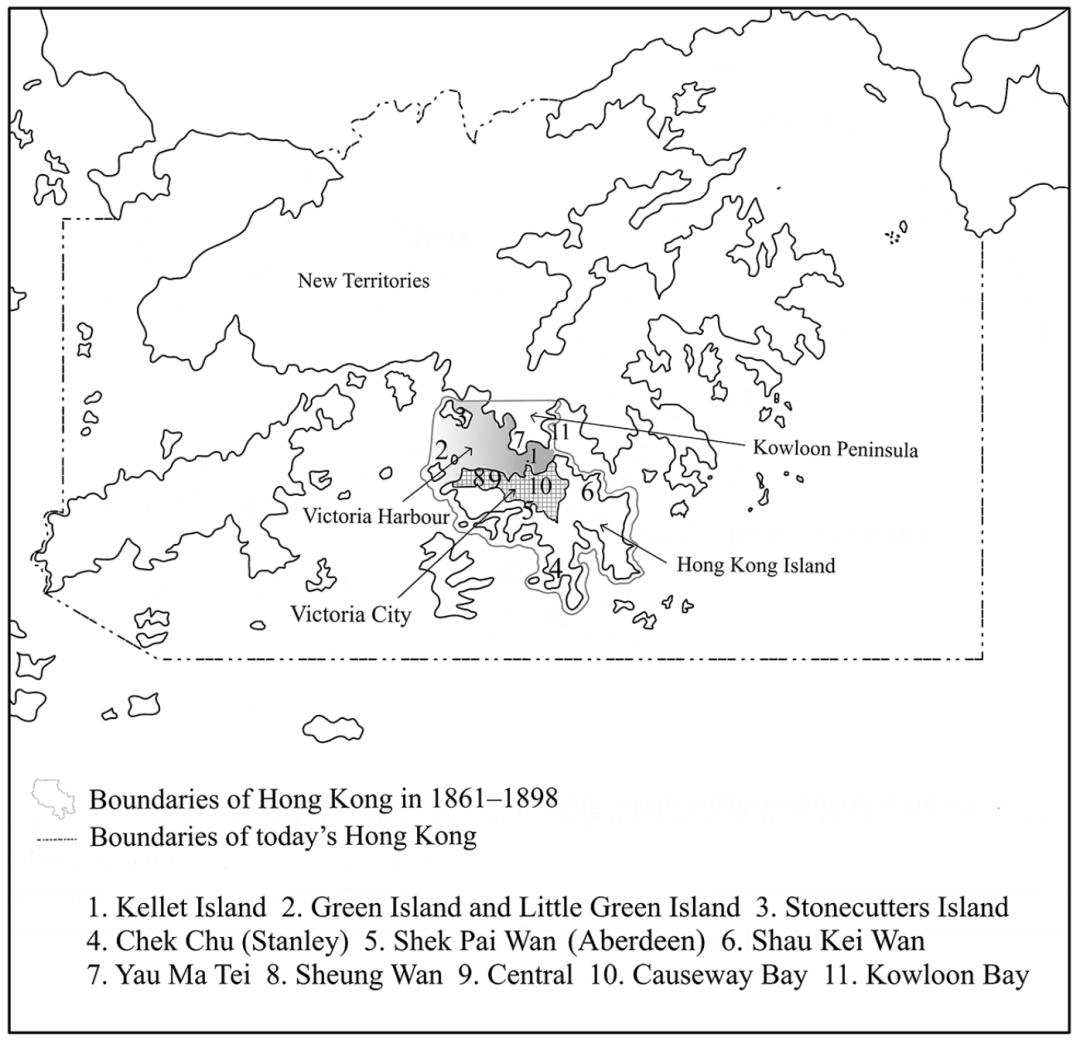
(图 1) 香港地图
(Figure 1) Map of Hong Kong
本文分析了有关英国对香港滨海空间的统治及其实际使用情况的各类官方与非官方史料。文章大量利用英国国家档案馆中的殖民地部档案(CO 129档案)、《香港政府宪报》以及地方条例汇编。许多香港的历史地图与照片,将港湾的官方划界与实际状态可视化。为理解殖民规章如何运作,以及船只及其所有者——尤其是中国人——如何抵抗英国统治或与之协商,本文查阅了刑事记录、香港出版的报纸以及华人的早期请愿书。下文图1展示了香港、维多利亚港、维多利亚城的范围,以及文中讨论的主要地点。
This article analyses various official and unofficial sources concerning both British rule over littoral space and its actual use in Hong Kong. It draws extensively on Colonial Office records (CO 129 files) in the UK’s National Archives, The Hongkong Government Gazette, and collections of local ordinances. Many historical maps and photographs of Hong Kong visualize the official demarcation and actual status of the harbour. To understand how colonial regulations operated and how watercraft and their owners (particularly Chinese ones) resisted against or negotiated with British rule, this article consults criminal records, newspapers published in Hong Kong, and early petitions from the Chinese. Figure 1 below shows the spheres of Hong Kong, Victoria Harbour, Victoria City, and the major places discussed in the article.
I
英国人将19世纪的香港从一组此前处于清朝统治之下的渔村与农庄,转变为一个转口港。1841年6月,香港成为自由港,各国贸易船舶均免缴进口税或出口税。尽管期间有经济衰退与社会动荡的间歇,19世纪后半叶进出香港的商船数量与吨位仍持续增加。这一商业增长既包括西方商船,也包括中国“戎克船”(关于该术语下文详述)。1875年访港时,美国教育家沃伦·克拉克回忆道:“每日驶入并离开此港的[贸易]船只数量之多,令人惊讶。” 它们大多停泊在维多利亚港;维多利亚港位于香港岛与九龙半岛之间、毗邻维多利亚城。1891年,据称有近4万艘商船使用该港。“到19世纪末,维多利亚港已录得世界上任何港口中最大的年度吨位周转量之一。”
The British transformed nineteenth-century Hong Kong from a cluster of fishing and farming villages previously under Qing rule into an entrepôt. In June 1841, Hong Kong became a free port where trading ships of all nationalities were exempt from import or export charges. Despite intervals of recession and social unrest, the number and tonnage of merchant ships arriving in and leaving Hong Kong continued to increase during the second half of the nineteenth century. This commercial growth included both Western merchantmen and Chinese ‘junks’ (more on the term below). Visiting Hong Kong in 1875, E. Warren Clark, an American educator, recalled that ‘the number of [trading] vessels daily arriving and departing from this port is surprising’. Most of them anchored in Victoria Harbour, which lay off Victoria City between Hong Kong Island and Kowloon Peninsula. In 1891, nearly 40,000 merchant vessels reportedly used the harbour. ‘By the end of the century Victoria Harbour registered one of the largest annual turnovers in tonnage of any port in the world.’
繁忙的维多利亚港中的航运并不限于贸易船舶。与亚洲其他殖民港口城市一样,香港是不同国籍、不同类型的国际性、区域性与地方性船只的中转点、目的地或母港。香港是远洋运输与中国移民的亚太枢纽,许多旅客在此登船。除商船外,运送补给品的区域性船只、地方货船以及中国渔船也常出入该港及香港其他水域。在军事方面,自1844年起,香港成为皇家海军中国舰队总部,许多英国及外国军舰都曾到访香港。
Shipping in the busy Victoria Harbour was not limited to trading vessels. Like other colonial port cities in Asia, Hong Kong was a transit point, destination, or home of international, regional, and local watercraft of different nationalities and types. Hong Kong was an Asia-Pacific hub of oceanic transport and Chinese emigration where many passengers embarked. Apart from merchant vessels, regional watercraft carrying provisions, local cargo boats, and Chinese fishing craft frequented the harbour and other waters in Hong Kong. Militarily, many British and foreign ships of war visited Hong Kong, from 1844 onwards the headquarters of the Royal Navy’s China Station.
在技术层面,蒸汽航行在全球的普及改变了19世纪后半叶维多利亚港的面貌。根据一份注明1888年日期的政府报告,
Technologically, the global popularization of steam navigation transformed the appearance of Victoria Harbour in the second half of the nineteenth century. According to a government report dated 1888,
“二十七年前,轮船尚属例外,而帆船才是常态……那时一艘轮船的平均吨位不过略高于一千吨,而如今同时在港内见到三四艘各自达3000至4000吨以上的轮船,已并不罕见。”
Twenty-seven years ago steamers were the exception, and sailing ships the rule…The average tonnage of a steamer then was very little over one thousand tons, whereas now it is no uncommon thing to see three or four steam-ships in Port at one time each measuring from 3 to 4000 tons and upwards.
蒸汽航运兴起的一个重要因素,是1869年苏伊士运河的开通。根据1871年一份地方行政报告,运河开通“已经对增加轮船数量产生了巨大影响”。许多历史照片都展示了大小不一的轮船与帆船混杂占据繁忙港湾的景象。
One major factor for the rise of steam shipping was the opening of the Suez Canal in 1869. According to a local administrative report of 1871, the opening ‘has already had a great effect in increasing the numbers of Steamers’. Many historical photographs show a mixture of steamers and sailing craft in various sizes occupying the bustling harbour.
不断增长的航运不仅给香港带来利润,也带来了威胁。殖民当局忧虑中国犯罪分子会由外海进入。就经济而言,海盗、走私及其他水上秘密活动可能危及贸易与其他行业。就社会而言,人们反复担心来自世界不同地区的疫病,会通过驶入维多利亚港的船舶传播到殖民地。19世纪后期,一位香港总督——殖民地中的最高当局——写道:“霍乱、天花以及其他传染性与感染性疾病,经常在中国、印度、日本、马尼拉、西贡、新加坡以及与香港保持持续交通往来的其他邻近港口与国家流行。” 在诸如19世纪90年代鼠疫大流行期间,商用轮船上的确出现过疫病病例。殖民者对港湾的态度混杂着希望、忧虑与恐惧。
Increasing shipping brought not only profits but also threats to Hong Kong. Colonial authorities were anxious about Chinese criminal elements coming by the open sea. Economically, piracy, smuggling, and other clandestine activities on water could jeopardize trade and other sectors. Socially, there were recurrent worries of the spread of epidemics from different parts of the world to the colony via vessels entering Victoria Harbour. In the late nineteenth century, a governor of Hong Kong, the highest authority in the colony, wrote: ‘Cholera, small-pox, and other infections and contagious diseases are frequently rife in China, India, Japan, Manila, Saigon, Singapore, and in the other neighbouring ports and countries, between which and Hongkong there is constant communication.’ Epidemic cases did occur on merchant steamers, during, for example, the bubonic plague of the 1890s. Colonial attitudes towards the harbour were mixed with hopes, worries, and fears.
鉴于维多利亚港的重要性及其伴随而来的威胁,如何将其纷繁复杂的航运纳入控制,始终是香港殖民统治者的一项重大治理任务。英国针对维多利亚港的规制,可追溯至1841年4月,当时维多利亚城开始出现。行政上,港务处负责管理港务事务。其首长为港务长,同时兼任海事裁判官,负责审理违反港口规章者。1861年九龙割让之后,又颁布了更多法律来规制该港。例如,1862年,立法机关通过了《规制与管制香港维多利亚港条例》。一系列行政命令则补充了与港口相关的立法。
Given Victoria Harbour’s importance and concomitant threats, how to bring its myriad shipping under control remained a major governing task for colonial rulers in Hong Kong. British regulations on Victoria Harbour are traceable to April 1841, when Victoria City started to emerge. Administratively, the harbour master’s office oversaw the harbour affairs. Its head was the harbour master, who was also the marine magistrate responsible for trying offenders who breached harbour regulations. Following the cession of Kowloon in 1861, more laws were proclaimed to regulate the harbour. In 1862, for example, the legislature passed the ‘ordinance for the regulation and control of the Harbour of Victoria, Hongkong’. An array of executive orders supplemented the harbour-related legislation.
总体来看,繁多的港口规章展示了英国在维多利亚港营造有序环境的努力。它们对船只自进入港口至离开港口的整个过程,施加了日益细密的要求。这构成了规制城市人口诸条例的一种“滨海版本”。各国商船都必须申请登记、放行证、执照或特别许可证。具体规定说明了应悬挂何种旗帜与号码、应使用何种灯号与信号,以及船只在不同情况下应如何停泊。规章还限制夜间对港湾的使用,例如禁止日落后敲锣、燃放烟火以及未经授权的移动。它们也约束船上活动,如火药储存与水手行为。
Taken as a whole, the myriad harbour regulations demonstrate British efforts to create an orderly environment in Victoria Harbour. They imposed progressively detailed requirements on watercraft throughout the period of their arrival in and departure from the harbour. These entailed a ‘littoral version’ of the ordinances that regulated the urban population. Merchantmen of all nationalities had to apply for registers, clearances, licences, or special permits. Specific stipulations described what flag and numbers had to be hoisted, what lights and signals had to be used, and how ships had to be anchored on different occasions. Regulations restricted the nocturnal usage of the harbour such as prohibiting gong beating, fireworks, and unauthorized movements after sunset. They also constrained activities on board ships such as gunpowder storage and seamen’s behaviour.
除港口规章外,许多地方法律也规制维多利亚港及其航运。例如,反海盗立法允许搜查并解除中国船只武装。有关搭载中国移民船只的规则,则意在限制被批评为不人道的“苦力”贸易。此外,许多地方法律具有“水陆两栖性”。例如,1867年的传染病条例同时规制妓院,以及殖民地水域中任何船只上的卖淫活动。
Apart from the harbour regulations, many local laws regulated Victoria Harbour and its shipping. For example, the anti-piracy legislation permitted searching and disarming Chinese vessels. The rules on ships with Chinese emigrants aboard served to confine the ‘coolie’ trade criticized as inhumane. Moreover, many local laws were ‘amphibious’. For example, the 1867 contagious disease ordinance regulated both brothel houses and prostitution found on any craft in the colonial waters.
英国对维多利亚港的控制延伸到了其岛屿。在香港岛与九龙半岛之间,奇力岛自1841年起便设有一处炮台。1861年九龙割让后,奇力岛成为一座军火库。港内其他岛屿包括位于香港岛西北端外海的青洲及其相邻的小青洲。1875年,殖民当局在青洲修建了一座灯塔。位于港湾西北角的昂船洲地处僻静。如下文所述,这一位置对殖民地的行政、医疗与军事用途都很有帮助。
British control over Victoria Harbour extended to its isles. Between Hong Kong Island and Kowloon Peninsula, Kellet Island had been the site of a battery since 1841. After the 1861 cession of Kowloon, Kellet Island became a military magazine. Other isles within the harbour included Green Island and the adjoining Little Green Island off the north-western tip of Hong Kong Island. In 1875, colonial authorities built a lighthouse on Green Island. At the harbour’s north-western corner, Stonecutters Island enjoyed a secluded position. As discussed below, this proved useful for the colony’s administrative, medical, and military purposes.
殖民当局从未忽视维多利亚港之外的海岸、水域与岛屿。许多港口规章涉及殖民地全部滨海边缘地带。在海军炮艇协助下,港务处与水警的艇队沿岸巡逻——与陆上治安巡逻类似。港务处虽设于面向维多利亚港的维多利亚城内,但其分支机构称为“港务站”,分别驻守于城东的 Shau Kei Wan,以及香港岛南部的 Chek Chu(赤柱)与 Shek Pai Wan(香港仔)。警署也驻守于 Chek Chu 与 Shek Pai Wan。此外,港务长还管理香港周边的灯塔。作为埃里克·塔利亚科佐所谓的“殖民治理技术”,这些灯塔为进入香港水域的船只指引航路。到19世纪后期,英国殖民政府已经建立起对环绕香港岛与九龙半岛的岛屿和水域的控制。
Colonial authorities never lost sight of the shores, waters, and isles beyond Victoria Harbour. Many harbour regulations concerned the entire littoral fringes of the colony. Aided by naval gunboats, flotillas of the harbour master’s office and water police patrolled the shores – similar to policing on land. While the harbour master’s office was in Victoria City facing Victoria Harbour, its branches called ‘harbour master’s stations’ presided over Shau Kei Wan east of the city, and Chek Chu (Stanley) and Shek Pai Wan (Aberdeen) in southern Hong Kong Island. Police stations also guarded Chek Chu and Shek Pai Wan. Moreover, the harbour master managed lighthouses around Hong Kong. As ‘technologies of colonial governance’ (Eric Tagliacozzo’s term), these lighthouses guided vessels entering the waters of Hong Kong. By the late nineteenth century, the British colonial government had established control over the isles and waters surrounding Hong Kong Island and Kowloon Peninsula.
II
1841年之前,清朝当局运用“内”与“外”这一组关系性概念来理解中国的海洋区域,并据此组织行政责任。在这一二元框架下,香港地区的某些部分(例如九龙近海水域)位于“内洋”(neiyang)之内,而其他部分(例如 Shek Pai Wan)则位于“外洋”(waiyang)之内。一般而言,内洋地区所受清朝行政与军事控制,比外洋地区更为严密。然而,到了1841年,环绕英属香港的全部水域都变成了“外国海域空间”——借用罗纳德·波的术语——清朝当局不再能对其施加任何有效控制。如下面所示,英国规章对香港水域的分类与划分,不再依据行政与军事责任,而是依据功能。
Before 1841, Qing authorities applied the relational concepts of ‘inner’ and ‘outer’ to conceptualize China’s maritime regions and organize administrative responsibilities accordingly. Under this binary framework, some parts of the Hong Kong region (e.g. the waters off Kowloon) lay within the ‘inner waters’ (neiyang) and others (e.g. Shek Pai Wan) within the ‘outer waters’ (waiyang). Generally speaking, inner-water regions were subject to a tighter administrative and military grip of the Qing than outer-water regions. In 1841, however, all the waters surrounding British Hong Kong became ‘foreign sea space’ (to borrow Ronald Po’s term) upon which Qing authorities no longer exerted any kind of effective control. As shown below, British regulations classified and divided the Hong Kong waters not in terms of administrative and military responsibilities but in terms of functions.
(图 2) 维多利亚港,1889年
(Figure 2) Victoria Harbour, 1889
英国殖民统治者将另一套概念与措施施加于香港,以划分并统治其滨海空间及船只。首先,1845年,他们划定了维多利亚港。1861年,九龙半岛被纳入殖民地,这促使政府重新界定港湾范围。与1845年的界限相比,1862年的修订(见图2)纳入了青洲,却排除了九龙界线以北的水域。这表明,界定港湾空间的是行政关切,而非自然地貌。
British colonial rulers imposed on Hong Kong a different set of concepts and measures to divide and rule its littoral space and watercraft. First, in 1845, they delineated Victoria Harbour. In 1861, the incorporation of Kowloon Peninsula into the colony propelled the government to redefine the harbour sphere. Compared with the 1845 limits, the 1862 revision (see Figure 2) included Green Island but excluded the waters north of the boundary of Kowloon. This demonstrates that administrative concerns rather than natural features defined the harbour space.
在被清晰界定的维多利亚港之内,殖民当局为不同船只的使用划出了不同空间。技术发展、种族因素、海军需求与公共卫生关切,都影响了这种划分。首先,当蒸汽航行日益普及时,他们为轮船划出了航行空间。1859年11月,政府在港内设立了一条轮船航道。一张1863年的地图将这条航道标示为“河运轮船通道”。带有编号并涂漆的浮标界定了该航道。例如,“五个浮标的内线平均距离海岸200码,彼此相距450码,漆为红色,并标有1至9之间的奇数号码。” 类似于维多利亚城中供马匹与车辆通行的公共大道,任何船只都不得阻塞维多利亚港内的轮船航道。随着港内蒸汽航行进一步增长,1886年,殖民当局又将这条航道划分为北航道、中航道与南航道(图2)。
Within the clearly defined Victoria Harbour, colonial authorities designated spaces for the use of different ships. Technological development, racial factors, naval demands, and public health concerns impacted the demarcation. First, they carved out navigational space for steamers when steam navigation became increasingly common. In November 1859, the government established a steamer’s fairway through the harbour. An 1863 map labels this fairway as a ‘channel for river steamers’. Numbered and painted buoys demarcated the fairway. For example, the ‘inner line of Five Buoys is at an average distance of 200 yards from the shore, and 450 yards apart, painted Red, and marked with the odd numbers from 1 to 9’. Similar to public highways for horses and vehicles in Victoria City, no vessels could block the steamers’ fairway in Victoria Harbour. Aligning with the further growth of the harbour’s steam navigation, in 1886 colonial authorities divided the fairway into the northern, central, and southern fairways (Figure 2).
殖民当局还通过为船只指定锚泊点来组织港湾空间。港务长有权要求商船进入任何被指定的泊位。为固定锚泊点,当局修建了栈桥与码头,并设置系泊设施、浮标与航标。他们还为运送夜香与垃圾箱的船只、海军医院船,以及水警使用的一艘趸船指定了特定位置。
Colonial authorities also organized the harbour space by assigning anchorage points for ships. The harbour master held the power of requiring merchant vessels to take up any indicated berth. To fix anchorage points, the authorities constructed piers and wharves and placed moorings, buoys, and beacons. They assigned specific spots for boats carrying night soil and dust bins, naval hospital ships, and a hulk used by the water police.
第二次鸦片战争后,随着航运增加,殖民统治者为不同类别的船只创造了集体锚泊空间。其中之一,便是被归类为“戎克船”的中国船只。当局在为这些“戎克船”分配锚泊空间时,将种族关切考虑在内。
After the Second Opium War, with increasing shipping, colonial rulers invented collective anchorage space for different categories of vessels. One of them was the Chinese watercraft classified as ‘junks’. When assigning anchorage space for these ‘junks’, the authorities took racial concerns into consideration.
在解释这些种族关切之前,有必要先理解英国当局在香港如何将“戎克船”作为一种针对中国船只的殖民分类。一般而言,在英文档案中,这一术语可以指构造风格起源于中国、日本或东南亚的船舶。与其他航海术语——如“舢舨”——一样,“戎克船”在不同地方语境中的含义并不一致。在19世纪的香港,在英国殖民档案中,这一术语偶尔也包括非中国的亚洲船只,如“暹罗戎克船”与“槟榔屿船只”。然而,在多数档案中,加上修饰语后的术语——例如“官府戎克船”“商用戎克船”与“海盗戎克船”——指的是从十英尺长的桨艇到远洋帆船在内的各类中国官方与民间船只。汉斯·康拉德·范·蒂尔堡富有洞见地指出:“船只……通过用途、设计以及……国籍,而与其来源文化牢固相连。” 对许多殖民官员而言,戎克船是具有“本土”航海构造的中国船只,相对于西式构造的船只,它们适用不同的登记制度。
Before explaining these racial concerns, it is necessary to understand how British authorities in Hong Kong used ‘junks’ as a colonial category for Chinese watercraft. Generally speaking, in English-language records, the term could mean ships and boats of construction styles originating in China, Japan, or Southeast Asia. Like other nautical terms such as ‘sampans’, the meaning of ‘junks’ varied in local contexts. In nineteenth-century Hong Kong, in British colonial records, the term occasionally included non-Chinese Asian vessels such as ‘Siamese junks’ and ‘Penang vessels’. In most records, however, the modified term – ‘mandarin junks’, ‘merchant junks’, and ‘piratical junks’, for example – denoted an array of Chinese official and unofficial watercraft from ten-feet-long oared boats to seagoing sailing vessels. Hans Konrad Van Tilburg has insightfully argued that ‘vessels are…firmly bound to their culture of origin by use, by design, and by…nationality’. For many colonial officials, junks were Chinese watercraft with ‘indigenous’ nautical structures subject to distinct registration vis-à-vis vessels of Western construct.
尽管香港殖民官员对“戎克船”一词缺乏连贯一致的理解,他们无疑是按种族视角来看待戎克船的。《政府宪报》有时将“戎克船”译作 Huachuan,这一词在殖民档案中经常用来指称中国式构造并由中国人使用的船只。在官方航运报告中,由中国人主导的“戎克船贸易”的统计,与外国商船航运的统计彼此分开。许多针对“戎克船”的殖民规章,如1847年的反海盗条例,都是带有种族歧视性的,因为它们主要针对中国船主与船员。
Although colonial officials in Hong Kong lacked a coherent understanding of the term ‘junks’, they certainly saw junks along racial lines. The government gazette sometimes translated ‘junks’ into Chinese as Huachuan, a frequent term in colonial records for craft of Chinese construct and employed by the Chinese. In official shipping reports, statistics about the Chinese-dominated ‘junk trade’ are separate from those about foreign merchant shipping. Many colonial regulations against ‘junks’ such as the anti-piracy ordinance of 1847 were racially discriminatory as they primarily concerned Chinese ship owners and crew.
1866年,殖民政府颁布了《关于更妥善规制与管制经常往来香港水域若干船只的条例》。这是另一部以中国船只为对象、受种族考量驱动的法律。在官方通信中,这部法律被简称为“戎克船条例”,其目的在于通过监督访问殖民地的无照中国船只来压制海盗行为。对总督理查德·麦克唐奈尔而言,这部条例有助于获取“关于这些水域中所有本地船只的动向与性质的信息[原文着重]”。
In 1866, the colonial government promulgated the ‘ordinance for the better regulation and control of certain vessels frequenting the waters of Hongkong’. It was another racially driven law targeting Chinese watercraft. This ‘junk ordinance’, as abbreviated in official correspondence, aimed at suppressing piracy by supervising unlicensed Chinese watercraft that visited the colony. For Governor Richard MacDonnell, the ordinance served to obtain ‘information as to the movements and character of all Native craft in these waters [emphasis added]’.
根据1866年的戎克船条例,来访的戎克船必须登记,并在维多利亚港内或港外停泊于港务长所划定的某一处“戎克船锚地”之内。这些“戎克船锚地”的官方中文名称,显示了其种族性质:《政府宪报》将其标识为 Tangchuan wanbo,即“唐船锚泊地”。Tang(粤语作 Tong)过去如此,今天仍然是中国人与中国事物的常用称谓。例如,在英国殖民档案中,Tangren 与 Tangguan 分别代表香港的华人臣民与清中国的官员。另一例子是 Tong lau,这是对华人租住楼宇的一种常见称谓。因此,在殖民档案中,Tangchuan wanbo 中的 Tang 这一修饰语反映了香港戎克船的“华人性质”。Tangchuan wanbo 是殖民当局为来港数量不断增加的中国船只所指定的锚地。
Under the 1866 junk ordinance, visiting junks had to be registered and berthed within or outside Victoria Harbour in one of the ‘anchorages for junks’ delineated by the harbour master. The official Chinese name of these ‘junk anchorages’ demonstrates their racial nature: the government gazette identified them as Tangchuan wanbo, that is, ‘anchorages for Tang ships’. Tang (Tong in Cantonese) was – and is still – a common descriptor for Chinese people and things. For example, in British colonial records, Tangren and Tangguan represent Hong Kong’s Chinese subjects and Qing China’s officials, respectively. Another good example is Tong lau, a common denomination for Chinese tenements. In the colonial archives, therefore, the modifier of Tang in Tangchuan reflects the ‘Chinese nature’ of junks in Hong Kong. Tangchuan wanbo were the anchorages assigned by colonial authorities for Chinese watercraft visiting Hong Kong in increasing numbers.
戎克船锚地的位置,展示了香港殖民当局如何隔离锚泊空间,以及种族如何影响这种空间与陆地空间的附着关系。考虑到中国海上贸易的增长,政府将中国商船的锚地设在本地华人聚落旁边。1866年维多利亚港内的戎克船锚地以两个红色浮标标示,毗邻 Sheung Wan 区——这是19世纪香港一个主要的华人城市聚落。那里聚集了许多 Nam Pak Hong(字面义为“南—北行”)——与中国沿海及东南亚进行贸易的华商行号。停泊在 Sheung Wan 外海的商船分类,显示出维多利亚港内的戎克船锚地与维多利亚城中的“南—北”贸易之间存在强烈联系。分类后的戎克船必须按自东向西的顺序停泊,依次为:“广州[Guangzhou]及澳门船”“东海岸船”(来自广州以北港口)“西海岸船”(来自海南)以及“新加坡戎克船”。这些名称显示了它们所从事的“南—北”贸易。1886年,殖民当局又在维多利亚港内增设了一处戎克船锚地。旧锚地与新锚地横跨 Sheung Wan 至维多利亚城西端一带华人居住与商业区外的水域。
The locations of the junk anchorages demonstrate how colonial authorities in Hong Kong segregated anchorage space and how race affected its attachment to land space. Considering the growth of Chinese maritime trade, the government designated anchorage areas for Chinese merchant vessels next to the local Chinese settlements. Marked with two red buoys, the 1866 junk anchorage in Victoria Harbour adjoined Sheung Wan district, a major Chinese urban settlement in nineteenth-century Hong Kong. It was home to many Nam Pak Hong (lit. south–north firms) – Chinese firms in trade with coastal China and Southeast Asia. The categorization of the merchant vessels berthing off Sheung Wan indicates the strong connection between the junk anchorage in Victoria Harbour and the ‘south–north’ business in Victoria City. The classified junks had to anchor from east to west in this order: ‘Canton [Guangzhou] and Macao Boats’, ‘East Coast Boats’ (from ports north of Guangzhou), ‘West Coast Boats’ (from Hainan), and ‘Singapore Junks’. These names indicate their ‘south–north’ trade. In 1886, colonial authorities assigned an additional junk anchorage in Victoria Harbour. The old and new junk anchorages extended across the waters off the Chinese residential and commercial districts from Sheung Wan to the western end of Victoria City.
维多利亚港外的戎克船锚地也显示,香港的一部分滨海空间如何被种族化隔离并附着于陆地空间。1866年,殖民政府在 Chek Chu、Shek Pai Wan 与 Shau Kei Wan 设立了戎克船锚地,均靠近各自的港务站。Chek Chu 在英国统治之前已是一个沿海华人市镇,Shek Pai Wan 则是一处海港,而 Shau Kei Wan 则是在1841年后出现了新兴的华人沿海社群。1886年,政府又在 Yau Ma Tei——九龙西岸一个正在兴起的华人市镇——为戎克船划设了新锚地。
Junk anchorages outside Victoria Harbour also show that some littoral space became racially segregated and attached to land space in Hong Kong. In 1866, the colonial government established junk anchorages at Chek Chu, Shek Pai Wan, and Shau Kei Wan near their respective harbour masters’ stations. Chek Chu was already a coastal Chinese market town and Shek Pai Wan a seaport before British rule whereas Shau Kei Wan saw an emerging Chinese coastal community after 1841. In 1886, the government assigned a new anchorage for junks at Yau Ma Tei, a burgeoning Chinese market town on the western coast of Kowloon.
英国的“仁慈”也促成了中国航运的种族隔离,这从避风港的案例中可见一斑。1874年一场破坏性台风之后,政府在铜锣湾设立了一处“避风港”,供小艇与“行动迟缓而笨重的载货驳船”使用。对总督约翰·轩尼诗而言,1883年为在维多利亚港划定避风空间而修筑的防波堤(见图2),目的在于“保护华船人口”。中国舰队的英国海军司令阿尔弗雷德·赖德则从种族角度更明确地描述了这一避风处。在他看来,它是为“香港的本地船只”而设。
British benevolence also contributed to the racial segregation of Chinese shipping, as shown by the case of the typhoon shelter. After a destructive typhoon in 1874, the government established a ‘harbour of refuge’ in Causeway Bay for small boats and ‘slow and unwieldy cargo lighters’. For Governor John Hennessy, the breakwater constructed in 1883 to delimit shelter space (see Figure 2) in Victoria Harbour aimed ‘for the protection of the Junk Population’. The British naval commander of the China Station, Alfred Ryder, described the refuge from a racial angle more explicitly. For him, it catered for ‘native boats at Hongkong’.
比较香港的陆地区域与滨海区域,可以看出殖民统治者在海岸两侧为种族性空间隔离辩护时所使用的相似逻辑。在戎克船锚地与避风港的案例中,船舶类型构成了一种非种族性的说辞,掩盖了实际上按种族为中国船只划定锚泊空间的做法。这与战前殖民地在陆地上的种族性居住隔离政策相似;后者依赖于官方要求在同一街区——例如香港岛山顶区——内保持建筑物相同的“类型”与“风格”。
A comparison between the land and littoral regions of Hong Kong reveals the similar logic used by colonial rulers to justify the racial segregation of space across the shore. In the cases of the junk anchorages and typhoon shelter, nautical types constituted a non-racial claim that veiled the actual racial delineation of anchorage space for Chinese watercraft. This is analogous to the pre-war colonial policy on racial-residential segregation on land, which depended on the official requirement of keeping buildings in the same ‘type’ and ‘style’ in the same neighbourhood such as Peak District on Hong Kong Island.
种族并非香港官方组织锚泊空间的唯一因素。海军需求同样重要。殖民当局在维多利亚港内为皇家海军与外国海军舰只保留了“军舰锚地”。其历史可追溯至第二次鸦片战争期间,当时大量英国武装船只集中于香港。1858年10月,港务长划定了一处军舰锚地;一个黑白相间的浮标标示了其西界与北界的交点。任何未经授权的民用船只都不得停泊于这一指定的海军空间之内。
Race was not the only factor for the official structuring of anchorage space in Hong Kong. Naval concerns also mattered. Colonial authorities reserved ‘men-of-war anchorages’ for Royal Navy and foreign naval ships in Victoria Harbour. Their history is traceable to the Second Opium War, when many British armed vessels concentrated in Hong Kong. In October 1858, the harbour master delimited a men-of-war anchorage; a buoy in chequered black and white marked the intersection of its western and northern boundaries. No unauthorized civilian vessel could anchor within the designated naval space.
英国及其他军舰体型的增大,导致维多利亚港内指定海军空间的扩张。中国舰队的皇家海军舰只最能反映航海技术对港内海军航运规模的影响。1862—3年,该舰队旗舰为“尤里阿勒斯号”,这是一艘虽以蒸汽驱动、但仍为木壳的护卫舰,吨位为3125吨,长212英尺。1889—94年,旗舰则是“因佩里厄斯号”,这是一艘大得多的钢壳蒸汽舰,吨位为8500吨,长315英尺。海军舰只体型与吨位的这种增长,导致1891年在九龙半岛又增设了一处军舰锚地。
The increase in the size of British and other ships of war resulted in the expansion of designated naval space in Victoria Harbour. The Royal Navy ships of the China Station best reflect the impact of nautical technology on the volume of the harbour’s naval shipping. The station’s flagship in 1862–3 was the Euryalus, a steam-powered yet still wooden-hulled frigate of 3,125 tons and 212 feet long. In 1889–94, the flagship was the Imperieuse, a much larger steel-hulled steamship of 8,500 tons and 315 feet long. Such increase in the size and tonnage of the naval shipping led to the addition of another men-of-war anchorage at Kowloon Peninsula in 1891.
这两处军舰锚地,为殖民政策中由陆地向毗邻水域延伸空间提供了更多例证。第一处军舰锚地毗邻维多利亚城中的皇家海军船坞,第二处则位于九龙西侧,邻接半岛上的海军仓库(见图2)。许多历史地图与照片都显示,它们附属于沿岸海军设施。
The two men-of-war anchorages provide more examples of spatial extension from land areas to the adjacent waters in colonial policies. The first men-of-war anchorage neighboured the Royal Naval Yards in Victoria City, and the second one lay on the western side of Kowloon adjacent to the peninsula’s naval depot (see Figure 2). Many historical maps and photographs indicate their attached status to the coastal naval establishments.
除种族关切与海军需求外,殖民统治者在组织滨海空间时,还考虑隔离那些对香港构成危险的因素。这些因素包括罪犯。为缓解殖民地第一所监狱——维多利亚监狱——的拥挤状况,当局利用了位于维多利亚港东缘、距离维多利亚城三英里、距离九龙两英里的偏远岛屿昂船洲。1863年,一项地方条例宣布该岛为囚犯站,未经授权者或民用船只均不得前往。该岛也是一艘于1863年购置、用于关押囚犯的趸船的指定锚泊点。与此同时,政府在该岛东北端修建了一所新监狱。然而,1867年,政府因运营成本过高而放弃使用它。囚犯趸船也在同年停止运作。
Besides racial concerns and naval demands, colonial rulers considered insulating elements hazardous to Hong Kong when organizing its littoral space. These elements included criminals. To relieve overcrowding in Victoria Gaol, the colony’s first prison, the authorities made use of Stonecutters Island, a remote isle on Victoria Harbour’s eastern edge, three miles from Victoria City and two miles from Kowloon. In 1863, a local ordinance declared the island a convict station that no unauthorized person or civilian craft could visit. It was also the designated anchorage point of a hulk purchased in 1863 for housing convicts. Meanwhile, the government built a new gaol at the north-eastern end of the island. In 1867, however, the government abandoned it due to high operational cost. The convict hulk ceased operation in the same year.
殖民当局还利用维多利亚港内及其外侧水域中的偏远岛屿,来隔离火药、水雷与危险货物。1867年,政府要求所有民用船只若载有超过200磅的火药,便必须将其转移至昂船洲旁边的一艘官方趸船。后来,由于该趸船容量不足,当局又把废弃的昂船洲监狱改作另一处火药储存场所。到19世纪70年代,这座浮动火药库仍停留在东港界之外的九龙湾。1888年,政府在昂船洲以南水域设置了一片实验性水雷场(见图2)。两座涂有红白垂直条纹浮标上的航标界定了其南界。1892年,当局又在奇力岛与东港界之间的水域设立了一处“危险货物锚地”。装载石油等危险物品的船只必须停留在那里。
Colonial authorities also took advantage of remote isles in Victoria Harbour and waters beyond it to isolate gunpowder, submarine mines, and dangerous goods. In 1867, the government required all civilian vessels to remove gunpowder to an official hulk next to Stonecutters Island if the amount exceeded 200 pounds. Later, the hulk’s insufficient capacity propelled the authorities to turn the abandoned Stonecutters Island gaol into another site of gunpowder storage. In the 1870s, the floating gunpowder depot remained in Kowloon Bay just beyond the eastern harbour limit. In 1888, the government set up an experimental submarine minefield (see Figure 2) in the waters south of Stonecutters Island. Beacons upon two buoys painted with red and white vertical stripes defined its southern boundary. In 1892, the authorities established a ‘Dangerous Goods Anchorage’ in the waters between Kellet Island and the eastern harbour boundary. Vessels laden with dangerous items such as petroleum had to remain there.
公共卫生因素也影响了香港滨海空间的官方配置。塞西莉娅·朱与克里斯托弗·考威尔已展示出,健康关切与疾病对殖民城市形态具有多重重要性。当香港殖民统治者利用滨海空间来隔离不卫生或有害健康的对象时,这些因素同样发挥了作用。在他们看来,昂船洲、九龙湾以及小青洲与维多利亚城之间的分隔,使其成为对抗天花与霍乱等疫病、实施检疫与隔离的理想地点。它们在功能上相当于城市香港中的隔离病房与检疫医院。
Public health factors also influenced the official configuration of littoral space in Hong Kong. Cecilia Chu and Christopher Cowell have demonstrated the myriad significance of health concerns and disease to the colonial urban form. These factors also occurred when colonial rulers in Hong Kong used littoral space to segregate unhealthy elements. For them, the separation of Stonecutters Island, Kowloon Bay, and also Little Green Island from Victoria City made them excellent sites for quarantine and isolation against epidemics such as smallpox and cholera. They served comparable functions as isolation wards and quarantine hospitals in urban Hong Kong.
19世纪,在对疫病的恐惧之下对航运实施检疫,是一种由欧洲帝国强权输出到世界不同地区——如英属印度与澳大利亚——的国际实践。在香港,最早的海上检疫规章可追溯至1862年。19世纪60年代与70年代,小青洲、九龙湾与昂船洲都曾成为被检疫船只的临时锚地。与此同时,19世纪60年代,小青洲上还曾设有一处临时检疫站。1867年,英国海军当局利用废弃的昂船洲监狱,隔离天花病人。
In the nineteenth century, imposing quarantine on shipping amid epidemic fears was an international practice exported by European imperial powers to different parts of the world such as British India and Australia. In Hong Kong, the first maritime quarantine regulations are traceable to 1862. In the 1860s and 1870s, Little Green Island, Kowloon Bay, and Stonecutters Island became ad hoc anchorages for ships in quarantine. Meanwhile, a temporary quarantine station operated on Little Green Island in the 1860s. In 1867, British naval authorities used the abandoned Stonecutters Island prison to isolate patients with smallpox.
19世纪80年代初,霍乱疫情席卷中国东南沿海与菲律宾。为防止疫病经海路传入香港,殖民政府在昂船洲周围为入港船只及其船员划定了检疫区域。1883年7月,一项公告规定,凡自广东霍乱疫港汕头驶来的船只,必须悬挂适当的检疫旗——“黄旗”——并驶往昂船洲与青洲之间已划定的水域。它们必须停留在这一后来一项条例中被称为“检疫锚地”的区域内,等待卫生官员下达放行命令。在被扣留期间,任何人员或船只都不得接近它们。首批受到检疫令约束的船只,是“道格拉斯号”与“戴尔号”两艘轮船,船上有438名中国乘客,并出现若干霍乱病例。时任香港总督乔治·鲍恩自信地断言,正是由于这一检疫措施,维多利亚城中未发现任何霍乱病例。1883年9月,检疫规章又扩展适用于一切来自任何传染病流行地区的船只。
In the early 1880s, a cholera epidemic swept through the south-eastern coast of China and the Philippines. To prevent its spread to Hong Kong by sea, the colonial government fixed quarantine areas around Stonecutters Island for incoming ships and their crew. In July 1883, a proclamation stipulated that all vessels from Shantou, a cholera-infected port in China’s Guangdong Province, had to fly the proper quarantine flag – the ‘yellow flag’ – and proceed to the delineated waters between Stonecutters Island and Green Island. They had to remain in this ‘quarantine anchorage’ – as named in a later ordinance – pending the health officer’s release order. During the detention, no person or craft could approach them. The first ships subject to the quarantine order were the Douglas and Dale, steamers with 438 Chinese passengers and several cases of cholera. The then governor of Hong Kong, George Bowen, confidently concluded that thanks to the quarantine measure, no case of cholera was found in Victoria City. In September 1883, the quarantine regulations extended to ships from all places where any infectious disease prevailed.
殖民统治者还在昂船洲本岛上划定了检疫空间。根据1883年的检疫规章,一排黄旗在岛西部、靠近检疫锚地之处围出了一片检疫场地。凡由卫生官员从入港船只上移出的乘客与船员,都必须留在那里。起初,检疫场地上搭建的是临时帐篷。鲍恩总督颇为惊讶地指出,尽管霍乱、天花及其他传染病在中国及亚洲其他地区流行,香港却“很可能是大英帝国唯一一个没有 Lazaretto 的属地”,也即一所供海上旅客使用的检疫站兼隔离医院。因此,他于1883年提议在昂船洲建立一座永久性的 lazaretto;在他看来,昂船洲是“位于香港港口西北端的一座无人小岛……几乎仿佛是大自然专为一所 Lazaretto 而造。” 这座 lazaretto 于1886年建成,位于检疫场地之内。上述 lazaretto,以及航行、锚泊与检疫空间,显示出地方治理的不同关切如何推动殖民当局在19世纪香港的滨海空间上施加行政网格。
Colonial rulers also designated quarantine space on Stonecutters Island itself. Under the 1883 quarantine regulations, a line of yellow flags marked off a quarantine ground in the island’s western part near the quarantine anchorage. The passengers and crew removed from incoming vessels by the health officer had to remain there. At the beginning, temporary tents were pitched on the quarantine ground. Governor Bowen was surprised that although cholera, smallpox, and other infectious diseases were rife in China and other parts of Asia, Hong Kong was ‘probably the only dependency of the British Empire in which there is no Lazaretto’, that is, a quarantine station-cum-isolation hospital for maritime travellers. Accordingly, he proposed in 1883 to establish a permanent lazaretto on Stonecutters Island, ‘a small, uninhabited island at the Northwestern extremity of the harbour of Hongkong…which would almost appear to have been created by Nature for a Lazaretto’. Completed in 1886, the lazaretto was located within the quarantine ground. The lazaretto and navigation, anchorage, and quarantine spaces described above show how different concerns about local governance propelled colonial authorities to impose administrative grids on the littoral space of nineteenth-century Hong Kong.
III
在殖民地香港之外,英国对滨海空间的规制也发生在中国的条约港。在条约港中,管理港口与沿海航行的主要机构是中国海关总税务司署;这是清政府中的一个由英国职员主导、制度精密的涉外机构,其管辖范围远不止海关事务。其海务部门发布港口规章,并设有与香港对应者相似的港务长。亚洲其他英国殖民城市也有与香港港务长相当的港口管理机构。例如,在新加坡、孟买与加尔各答,港务监督在19世纪大部分时期负责港口发展与航运控制。
Beyond colonial Hong Kong, British regulations over littoral space also took place in the treaty ports of China. In the treaty ports, the chief agent managing harbours and coastal navigation was the Chinese Maritime Customs Service, a sophisticated foreign institution in the Qing government dominated by British staff whose jurisdiction included much more than customs affairs. Its marine department issued harbour regulations and included harbour masters, like their counterparts in Hong Kong. Other British colonial cities in Asia also had port authorities parallel to the harbour master in Hong Kong. In Singapore, Bombay, and Calcutta, for example, master attendants oversaw port development and the control of shipping for much of the nineteenth century.
与香港一样,帝国或殖民当局在中国条约港以及亚洲其他英国港口城市中,也划定了不同类型的航行、锚泊与检疫空间。在这些港口中,为蒸汽航行设置的航道十分常见。在上海与天津,港务长管理锚地,并维护有助于航行的灯塔、航标与浮标。他们还执行检疫规章,并为不同国籍的船只指定检疫空间。新加坡、孟买与加尔各答也都设有专为军舰、商船以及各种“本地”船只设计的锚泊空间。例如,在孟买,浮标标示了港口入口处的航道与军舰锚地。此外,还为不同吨位的船只设置了系泊处。
As in Hong Kong, imperial or colonial authorities delineated different kinds of navigational, anchorage, and quarantine spaces in China’s treaty ports and other British port cities in Asia. In these ports, fairways for steam navigation were common. In Shanghai and Tianjin, harbour masters managed anchorages and maintained lighthouses, beacons, and buoys that assisted navigation. They also enforced quarantine regulations and assigned quarantine spaces for ships of different nationalities. Singapore, Bombay, and Calcutta also had anchorage spaces designed for ships of war, merchant vessels, and ‘native’ vessels of different kinds. In Bombay, for example, buoys marked the fairway at the harbour’s entrance and the men-of-war anchorage. There were also moorings for vessels of different tonnage.
既有研究往往将亚洲殖民港口城市中已被划定的滨海空间——例如锚地与检疫站——分开考察。然而,如果将它们合并起来,并结合其与殖民陆地空间的地理关联来观察,则可辨认出这些被划定的滨海空间之间存在一种粗略的等级结构。这反映了殖民统治者如何理解不同船只的相对重要性与角色。就香港而言,轮船航道与英国军舰的第一处锚地位于核心港湾空间之内——即毗邻维多利亚城中环的深水区。第二处军舰锚地则占据九龙背风侧的一大片水域,那也是另一处更优越的港湾区段。相较之下,为中国航运划定的戎克船锚地与避风港,要么位于核心港湾区域两侧(Sheung Wan、Yau Ma Tei 与铜锣湾外海),要么位于维多利亚港之外(Shau Kei Wan、Chek Chu 与 Shek Pai Wan 外海)。港湾东缘则设有奇力岛的军事仓库及与之相邻的危险货物锚地。火药趸船与被检疫船只的泊位,则位于东港界之外的九龙湾。港湾西缘的青洲、昂船洲及其周边水域,则作为“不受欢迎的对象”的隔离空间而发挥作用,这些对象包括囚犯、爆炸物、被检疫的船只与船员,以及传染病患者。
Previous scholarship often examines demarcated littoral spaces – anchorage areas and quarantine stations, for example – in colonial port cities in Asia separately. Yet, if we consider them together and their geographical relevance with colonial land space, a rough hierarchy of the delineated littoral spaces is discernible. It reflects how colonial rulers understood the relative importance and roles of different watercraft. In the case of Hong Kong, the fairways for steamers and the first anchorage for the British men-of-war lay within prime harbour space – the deep waters next to Victoria City’s Central district. The second men-of-war anchorage occupied a huge area of waters on the lee of Kowloon, another superior harbour section. In contrast, the junk anchorages and typhoon shelter demarcated for Chinese shipping were on either two sides of the prime harbour areas (off Sheung Wan district, Yau Ma Tei, and Causeway Way) or outside Victoria Harbour (off Shau Kei Wan, Chek Chu, and Shek Pai Wan). The harbour’s eastern edge housed the military depot of Kellet Island and its adjoining dangerous goods anchorage. The berths of the gunpowder hulk and ships in quarantine lay in Kowloon Bay outside the eastern harbour limit. On the harbour’s western edge, Green Island, Stonecutters Island, and their waters functioned as isolated spaces for ‘undesirable elements’ including prisoners, explosives, ships and crew in quarantine, and contagious persons.
香港这些被划定的滨海空间所形成的等级结构,并非一项精心设计的殖民计划,而是政府利用维多利亚港内外水域与岛屿的诸多措施累积而成的结果。除了上文讨论的技术、种族、海军与卫生因素外,阶级也在滨海空间的组织中发挥了作用。英国当局虽然把西方商船航运视为殖民地转口贸易的基础,却认为戎克船贸易在与前者的竞争中必然衰落。事实上,戎克船航运与西方航运的比率的确持续下降。这解释了为何在滨海空间分配方面,主要为西方人所有的商用轮船比戎克船享有更多优先权。简言之,殖民当局对中国船只与西式船只经济角色的认知,影响了滨海空间的划分。
Rather than a carefully designed colonial plan, the emerging hierarchy of demarcated littoral spaces in Hong Kong resulted from an accumulation of government measures that utilized the waters and isles within Victoria Harbour and beyond. In addition to the technological, racial, naval, and health factors discussed above, class mattered in the organization of littoral space. While British authorities in Hong Kong considered Western merchant shipping the basis of the colony’s entrepôt trade, they believed the junk trade would inevitably decline in competition with the former. In fact, the ratio of junk shipping to Western shipping continued to decrease. This explains why predominantly Western-owned merchant steamers were privileged over junks in terms of the allocation of littoral space. In short, the colonial perception of the economic roles of Chinese and Western-styled ships influenced the division of littoral space.
此外,这种等级结构也揭示了英国官方对香港滨海地带的二分化处理。许多被指定的滨海空间,都是已开发陆地空间的镜像,甚至是其延伸。正如上文所示,航道以及检疫锚地与检疫站,在功能上可与城市中的干道与隔离医院相提并论。戎克船锚地毗邻本地华人聚落,而军舰锚地则邻接沿岸海军设施。这些滨海空间是供殖民当局认定对香港经济与安全至关重要的船只使用的。伴随着填海工程,政府致力于将这些滨海区域纳入其相邻的已开发陆地地区。与此同时,远离已开发地区的岛屿与水域——例如昂船洲与九龙湾——则充当“空间他者”,用以隔离那些被视为不受欢迎或具有威胁性的因素。到19世纪末,殖民统治者已无意将这类空间纳入香港的城市区域。
Moreover, the hierarchy reveals the British official bifurcation of littorals in Hong Kong. Many designated littoral spaces were mirrors and even extensions of developed land spaces. As shown above, fairways and quarantine anchorages and stations served comparable functions as urban thoroughfares and isolation hospitals. Junk anchorages neighboured the local Chinese settlements, and men-of-war anchorages adjoined the coastal naval establishments. These littoral spaces were for watercraft that colonial authorities found crucial for the economy and security of Hong Kong. Along with reclamation, the government strove to incorporate these littoral areas into their adjacent developed land regions. At the same time, isles and waters remote from developed areas – Stonecutters Island and Kowloon Bay, for example – functioned as the ‘spatial others’ that segregated elements considered undesirable or menacing. By the end of the nineteenth century, colonial rulers lacked any interest in incorporating such spaces into the urban areas of Hong Kong.
尽管关于某一殖民港口城市内部不同滨海空间之间关系的研究极少,将香港与新加坡作一简要比较,仍表明对滨海空间进行等级化与二分化使用,在亚洲殖民港口中相当常见。与香港一样,新加坡的航道与军舰锚地也位于核心港湾空间之内。与此同时,装载危险物品的船只所用锚地则远离殖民城市。此外,新加坡的一些偏远岛屿出于公共卫生关切,也发挥了与昂船洲相似的功能;在距新加坡殖民城市以南约三英里的岛屿上,曾设有检疫站与一座 lazaretto。新加坡圣约翰岛与香港昂船洲上的 lazaretto,都是19世纪世界各地建于远离城市与居住区岛屿之上的同类设施之一。
While scant scholarship has examined the relations between different littoral spaces in a particular colonial port city, a brief comparison of Hong Kong with Singapore suggests that the hierarchical and bifurcated use of littoral spaces was common in colonial ports in Asia. Like Hong Kong, the fairway and the men-of-war anchorage were located in prime harbour spaces in Singapore. Meanwhile, anchorages for ships laden with dangerous items lay far away from the colonial city. Moreover, some remote isles of Singapore served parallel functions as Stonecutters Island for public health concerns; quarantine stations and a lazaretto operated on isles about three miles south of Singapore’s colonial city. The lazarettos on St John’s Island in Singapore and Stonecutters Island in Hong Kong were among their nineteenth-century counterparts built on islands far away from urban and residential areas across the globe.
IV
各种力量都曾挑战殖民当局在香港规制滨海空间的努力。刑事记录便可证明这一点。单在1876年,就有64宗法庭案件涉及违反港口规章。1881年,这一数字升至125宗。1897年,34类犯罪中的670宗案件都涉及违反港口条例。其中数量最多的类别包括“船只——夜间九时至清晨鸣炮之间在岸边系泊”“夜间未悬挂灯号”以及“港内妨害秩序”。其他案件还包括船上盗窃、在禁时内击鼓以及燃放烟火。整个19世纪后期,本地报纸都会刊载裁判法院案件,其中警察与港务处人员逮捕了违反港口规章的罪犯。在这些案件中,多数违法者是中国人。例如,1873年,一名港务处官员目击并控告两名中国船夫向维多利亚港倾倒煤灰。另一次,1896年,一名警察则因一名中国船夫在其船上装载危险物品却未悬挂任何适当旗号,而将其逮捕。这些案件表明,殖民当局在繁荣的香港港口城市中规制滨海空间时面临着困难。
Various parties challenged colonial efforts to regulate littoral space in Hong Kong. Criminal records attest to this. In 1876 alone, 64 court cases concerned the breach of harbour regulations. In 1881, the figure rose to 125. In 1897, 670 cases in 34 categories of crime concerned violating the harbour ordinance. The largest categories included ‘Boats – Mooring in shore between the hours of 9 o’clock at night and gun-fire in the morning’, ‘neglecting to exhibit lights at night’, and ‘nuisances in harbour’. Other cases included onboard larceny, beating drums during prohibited hours, and discharging fireworks. Throughout the late nineteenth century, local newspapers published magisterial cases in which the police and the harbour master’s office staff captured culprits who violated the harbour regulations. In these cases, most offenders were Chinese. For example, in 1873, an officer of the harbour master’s office witnessed and charged two Chinese boatmen for throwing coal ash into Victoria Harbour. On another occasion, a policeman arrested a Chinese boatman in 1896 for having dangerous items on board his watercraft without any proper flag. These cases indicate the difficulties of colonial authorities in regulating littoral space in the thriving port city of Hong Kong.
滨海空间本身所具有的争议性,无疑加剧了这些挑战。随着不同类型、不同大小的船只数量增加,维多利亚港频繁成为船只碰撞、其他交通事故以及空间侵占事件的发生地。公私码头与栈桥是空间冲突的重要场所;1880年的裁判报告列出129宗“船民阻塞码头”的实例。1883年,本地报纸《香港电讯报》哀叹最古老的政府码头毕打码头“令人沮丧的严重不足”:“就其规模而言,它连应付这座美丽而繁盛城市交通的一半需要都远远不够。从早到晚,这一列木阶……都挤满了蒸汽小艇、军舰轻艇与大艇、船用小艇与住家艇,以及各种本地船只。” 直到20世纪之交政府重建美利码头与卜公码头,并兴建皇后像码头(皇后码头)后,毕打码头的过度使用才有所缓解。
The contested nature of littoral space certainly magnified these challenges. With increasing numbers of watercraft in various types and sizes, Victoria Harbour became the frequent site of clashes of ships, other traffic accidents, and incidents of spatial infringement. Government and private wharves and piers were major arenas of spatial conflicts; the magisterial report for 1880 listed 129 instances of ‘Obstruction of Wharves by Boat People’. In 1883, the local newspaper Hongkong Telegraph bemoaned ‘the miserable insufficiency’ of Peddar’s Wharf, the oldest government wharf: ‘In size it is not one half large enough for the traffic of this fair and flourishing city. From morning to night the flight of wooden steps…are crowded with steam launches, men-of-war gigs and cutters, ship’s and house boats, and native craft of every description’. Excessive usage of Peddar’s Wharf lessened only when the government rebuilt Murray Pier and Blake Pier and erected Queen’s Statue Wharf (Queen’s Pier) at the turn of the twentieth century.
反复发生的阻碍维多利亚港航道与锚泊空间的事件,也破坏了官方对滨海空间的划界。与维多利亚城中干道与街道持续被阻塞相平行,裁判记录中到处可见船只阻塞港内航道的事例。例如,1873年11月,一名港务处官员控告七名中国人将其船只停泊在航道之中,据称这“持续不断地构成滋扰”。许多货船在急于靠近装载货物的轮船时,阻碍了它们的航行。垃圾也使航道淤积。就锚泊空间而言,在军舰锚地内系泊以及对其海床进行疏浚的行为持续存在。此外,警方也常常捕获那些装载危险物品却停泊在危险货物锚地之外的船只。避风港启用后不久,抛入海中的垃圾便在其海底形成了“厚厚一层腐烂污秽物,散发出致命恶臭”。19世纪后期,许多中国船只还在这一季节性避风港内非法系泊。
Recurrent incidents of obstructing the navigational and anchorage spaces of Victoria Harbour also compromised official demarcation of littoral space. Parallel to the persistent obstructions of thoroughfares and streets in Victoria City, instances of boats blocking the harbour’s fairways abound in magisterial records. In November 1873, for example, an officer of the harbour master’s office charged seven Chinese individuals with anchoring their boats in the fairway, reportedly ‘a continual nuisance’. Many cargo boats obstructed the navigation of steamers laden with goods when rushing to approach them. Rubbish also silted the fairways. Concerning anchorage spaces, mooring within the men-of-war anchorages and dredging their ground persisted. Also, the police often caught craft laden with hazardous items and berthed outside the dangerous goods anchorage. Shortly after the typhoon shelter was open, refuse thrown overboard created ‘a layer of putrid offal which emits a deadly effluvium’ on the shelter’s seabed. In the late nineteenth century, many Chinese craft unlawfully moored in the seasonal typhoon shelter.
与城市香港的情形相似,在那里,不同利益群体之间的讨价还价塑造了其景观;在香港,殖民政府也就滨海空间的使用与其他各方进行协商。昂船洲便是一个极佳例子。起初,独立于地方行政机构之外的英国军方当局,虽然在岛上拥有土地,却并不反对在昂船洲兴建一座 lazaretto。后来,当他们在岛上修建炮台时,其卫生顾虑增加了。19世纪80年代后期,军方对 lazaretto 的抗议,促使政府将其关闭、移交军方,并不情愿地选择那一昂贵方案,即建造一艘“兼具传染病医院与检疫医院功能的趸船”,并将其停泊在昂船洲以北的一处海湾内。最终,1889年的《昂船洲条例》把整座岛及其周边水域都转变为军事区。军方当局最终取得了对该岛的专用权。这是英属香港诸多围绕空间使用而发生的军政冲突之一。
Similar to the case of urban Hong Kong, where bargains between different constituencies shaped its landscape, the colonial government negotiated with other parties over the use of littoral space in Hong Kong. Stonecutters Island is an excellent example. Initially, British military authorities – independent of the local administration – had no objection to erecting a lazaretto on Stonecutters Island even though they held land on the island. Later, their health concerns increased when they constructed batteries there. In the late 1880s, the military’s protest against the lazaretto propelled the government to close it, surrender it to the military, and reluctantly choose the costly option of building a hulk as ‘a combined epidemic and quarantine hospital’ and keeping it in an inlet north of Stonecutters Island. Finally, the Stonecutters Island ordinance of 1889 converted the whole isle and its surrounding waters into a military zone. Eventually, the military authorities acquired the island’s exclusive use. This is one of the many instances of civil–military conflicts over the use of space in British Hong Kong.
除军方当局外,非官方各方也争夺进入昂船洲的机会。尽管该岛先后作为囚犯设施、检疫区与军事区存在,私人猎人和游泳者仍从大陆一侧横渡海峡上岛。1875年,五名男女(国籍不详)非法登岛并偷窃岛上的水果。1895年,数名中国渔民甚至试图盗走划定已装药水雷范围的两个浮标与缆链。除私人经济利益外,气象因素也促成了围绕昂船洲使用而生的争议。其北侧海湾——传染病—检疫趸船停泊之处——在19世纪后期的台风季节,成了中国船只重要的“非官方”避风处。
Besides the military authorities, unofficial parties competed for access to Stonecutters Island. Despite its status first as a convict establishment and later as a quarantine and military zone, private hunters and swimmers crossed the strait from the mainland to the island. In 1875, five men and women (nationality unknown) illegally landed and stole fruit on the island. In 1895, several Chinese fishermen even tried to steal the two buoys and cable chain that demarcated the charged submarine mines. Besides private economic interests, meteorological factors contributed to the contested use of Stonecutters Island. Its northern inlet, where the epidemic-quarantine hulk anchored, was a major ‘unofficial’ shelter for Chinese watercraft during typhoon seasons in the late nineteenth century.
如上所述,为消灭香港水域周边的海盗活动,1866年的戎克船条例为中国船只指定了锚地。然而,与殖民地有关的海盗行为仍持续存在。表面上看,1866年后海盗问题似乎没有那么严重了。1872年至1881年间,地方司法机构平均每年审理的海盗案件不足五宗。然而,警务处长承认,这类报告表面上的缺乏,“是因为受害的戎克船民知道,英国当局不会在其管辖范围之外帮助追缉海盗船”。19世纪后期,报纸上反复出现的犯罪报道表明,用当时一位总督的话说,香港是“为海盗船提供装备、接收赃物并向从事这些恶行之人传递信息的据点”。Shau Kei Wan、Yau Ma Tei 等地的戎克船锚地成了海盗出没之所。警方经常在这些锚地上的船只中发现赃物。
As explained above, to eradicate piracy around the Hong Kong waters, the 1866 junk ordinance assigned anchorages for Chinese craft. However, piratical acts connected with the colony persisted. On the surface, piracy became a less serious problem after 1866. From 1872 to 1881, on average, the local judiciary annually tried less than five cases of piracy. Yet, the police chief admitted that the apparent lack of such reports was ‘due to the junk people who suffer being aware that no assistance is given by the British authorities to trace pirate boats beyond their jurisdiction’. During the late nineteenth century, recurrent newspaper reports of crimes indicate that Hong Kong – to use the words of a contemporary governor – was ‘a depot for the equipment of Piratical craft, the reception of booty, and the transmission of information to parties engaged in those nefarious pursuits’. The junk anchorages at Shau Kei Wan, Yau Ma Tei, and other places became pirates’ haunts. The police often found plunder on ships at these anchorages.
指定的戎克船锚地之所以未能消除海盗犯罪,部分原因在于官方能力的局限。港务处内部指令规定了毗邻戎克船锚地的各港务站负责人之职责:“登检所有到达该站的戎克船,并且每日两次,以及每周夜间两次在不固定时刻巡视‘戎克船锚地’,每次要求查验至少十艘船的‘锚地通行证’。” 然而,考虑到戎克船数量之多,这一指令是否可执行,实在可疑。有一次,在 Chek Chu 锚地,港务长看到“多达300艘此类船只于傍晚抵达,并在次日清晨全部离去”,并抱怨说,“要在如此短的时间内把它们全部查遍,是不可能的”。此外,缺乏有效的巡逻力量,以及港务处与水警之间的协调不善,也限制了他们在戎克船锚地及其之外查缉非法航运的能力。
The designated junk anchorages failed to eliminate piratical crimes partly due to limitations of the official capacity. The internal instructions of the harbour master’s office specified the duties of the heads of the harbour master’s stations next to the junk anchorages: ‘To board all Junks arriving at the Station and twice during each day, and twice during the night in each week at uncertain times to visit the “Junk Anchorage” demanding to see the “Anchorage Passes” of at least Ten Vessels on each occasion.’ However, given the sheer number of junks, it is doubtful whether this instruction was enforceable. On one occasion, at the Chek Chu anchorage, the harbour master saw ‘as many as 300 of these boats arrive in the evening and all leave the following morning’, and complained that ‘it is impossible to visit the whole of them in so short a time’. Moreover, the lack of an efficient patrol force and incoordination between the harbour master’s office and the water police limited their ability to check illegal shipping at the junk anchorages and beyond.
中国货船、渡船以及许多其他获得本地执照的“本地”船只,也使用香港的戎克船锚地。然而,殖民统治者远未能通过登记与人口普查来准确理解它们的数量与分布。在英属香港,对船只进行登记与计数始于19世纪40年代中期,但在殖民早期,这对遏制海盗与其他犯罪并无成效。自19世纪50年代后期起,登记与普查制度虽逐渐确立,但无照货船、渡船与渔船的问题在19世纪后期仍然存在。1870年至1900年间,仅在1872年、1877年、1881年与1897年进行过普查。这些不规则的普查未能提供中国船只的可靠数量。
Chinese cargo boats, ferries, and many other locally licensed ‘native’ watercraft also used the junk anchorages in Hong Kong. However, colonial rulers were far from acquiring an accurate understanding of their number and distribution through registration and census taking. Registering and counting boats in British Hong Kong began in the mid-1840s but proved ineffective in checking piracy and other crimes in the early colonial period. Registration and census regimes had become more established from the late 1850s onward, but the issue of unlicensed cargo boats, ferries, and fishing boats persisted in the late nineteenth century. Between 1870 and 1900, censuses took place in 1872, 1877, 1881, and 1897 only. These irregular censuses failed to provide a reliable number of Chinese watercraft.
此外,中国船只的流动性也限制了普查质量。例如,在1897年1月普查时,负责监督普查的总登记官表示,为迎接即将到来的中国新年,“不少渔船已按惯例前往澳门”。此外,“船只位置在很大程度上受天气影响,因而不足为凭”。在其中六艘船上,负责清点船只的普查员未能在一夜之间完成任务。当他们次日继续点算时,这些船已经移动了位置,而“要发现那些尚未编号的船只,自然就更困难了”。
Moreover, the mobility of Chinese watercraft limited the quality of the census. For example, at the time of the census taking in January 1897, the registrar-general, who oversaw the census, stated that ‘a number of fishing boats had gone, as is their custom, to Macao’ for the upcoming Chinese new year. Also, ‘the position of the boats is largely affected by the weather, and cannot be depended upon’. On board six boats, the enumerators of the watercraft failed to perform the task in just one night. When they continued the counting on the following day, the boats had already moved, and it ‘was naturally more difficult in discovering those which had not been numbered’.
中国船只的流动性也对抗了殖民当局限制其移动的努力。海盗问题便是明证。早在1841年之前,清朝就在香港地区进行过打击海盗的努力。1841年起成为该地区统治者的英国人,则带来了新的规则体系、殖民警察以及皇家海军,以打击海盗活动。此外,自19世纪40年代后期起,他们还与清朝官员及武装力量合作,在华南展开缉盗。然而,香港及其周边珠江三角洲地区的海盗活动依然持续。这是因为海盗袭击大多发生在超越英属香港与清中国水域之间行政边界的地区。它们经常发生在殖民地水域之外不远处,例如昂船洲与青洲外海。在这些区域,殖民地警察无权采取行动。此外,到19世纪后期,皇家海军已对只涉及中国人的海盗案件失去兴趣。至于清中国,其海上力量在通常发生海盗袭击的“外洋”区域内,总体上也相当薄弱。19世纪后期,英国与清朝的力量在压制香港周边海盗活动方面同样无能。
The mobility of Chinese watercraft also countered colonial efforts to restrict their movements. The case of piracy exemplifies this. Qing efforts to suppress piracy existed in the Hong Kong region long before 1841. The British, rulers of the region from 1841, brought with them new sets of rules, the colonial police, and the Royal Navy to combat piratical activities. Also, from the late 1840s, they co-operated with Qing officials and forces in piracy suppression in South China. Still, piracy persisted in Hong Kong and its surrounding Pearl River Delta region. This is because piratical assaults mostly took place in regions that transcended administrative boundaries separating the waters of British Hong Kong and Qing China. They frequently happened just beyond the colonial waters, in places such as the waters off Stonecutters Island and Green Island. In these regions, the colony’s police had no power to act. Moreover, in the late nineteenth century, the Royal Navy became uninterested in piratical cases that involved only the Chinese. As for Qing China, its maritime power was generally tenuous in the regions within the ‘outer waters’, where piratical attacks usually took place. British and Qing forces were equally incompetent in suppressing piracy around Hong Kong in the late nineteenth century.
除海盗之外,中国船只所有者还在其他情形下利用英属香港与清朝之间的水域行政边界,从事社会经济活动。现存华人向殖民政府提交的早期请愿书表明,中国商船、渔船与渡船的所有者,会向当局投诉清朝代理人在殖民地水域之内及之外的骚扰。此外,许多中国商人在香港为自有船只注册,并悬挂外国旗帜,以便在中国大陆享受关税豁免。走私则是海上人口的另一种跨境活动。例如,走私戎克船的船员在经陆路或海路将食盐销往中国大陆之后,于返航至 Yau Ma Tei——一处戎克船锚地所在地——途中从事海盗活动。如此一来,他们绕过了清朝的海关制度。
Aside from piracy, there were other situations where owners of Chinese watercraft took advantage of the administrative boundaries between the waters of British Hong Kong and Qing to pursue socio-economic activities. Existing early petitions from the Chinese to the colonial government show that Chinese owners of merchantmen, fishing boats, and ferries would complain to the authorities against harassment by Qing agents within the colonial waters and beyond. Moreover, many Chinese traders registered their own vessels in Hong Kong and hoisted a foreign flag to enjoy customs exemption in Chinese mainland. Smuggling was another transborder activity of the maritime population. For example, after disposing of salt in the Chinese mainland by land or sea, crews of smuggling junks engaged in piracy on their home runs to Yau Ma Tei, the location of a junk anchorage. In so doing, they circumvented the Qing customs regime.
因此,中国船只的操作者并非政府控制下的被动对象。许多中国船舶与小艇具有如此之强的流动性,以至于其活动超越了殖民当局施加于香港滨海空间上的行政网格。在更广阔、流动的华南水上世界中,中国人的海盗、走私与其他海上活动,削弱了英国殖民当局试图通过种族—空间隔离及其他划分方式,将维多利亚港及其他滨海地区纳入控制的努力。19世纪香港被划定的滨海空间等级结构,对中国船只而言意义甚微。它们横渡华南广阔区域的悠久航行历史,早于英国人的到来。总而言之,香港的案例显示,在亚洲殖民港口城市中,官方规制空间的努力常常与其实际使用相悖。这种情况横跨海岸两侧,发生在陆地空间与滨海空间之中。
Thus, operators of Chinese watercraft were not passive subjects of government control. Many Chinese ships and boats were so mobile that their activities transcended the administrative grids imposed by colonial authorities over the littoral space of Hong Kong. In the wider, fluid watery world of South China, Chinese piracy, smuggling, and other maritime ventures compromised the British colonial efforts to bring Victoria Harbour and other littoral regions under control by racial-spatial segregation and other kinds of division. The hierarchy of the demarcated littoral spaces in nineteenth-century Hong Kong meant little to Chinese watercraft. Their long history of sailing across extensive regions of South China predated the coming of the British. To sum up, the case of Hong Kong shows that official endeavours on regulating space in colonial port cities in Asia often ran contrary to its actual use. This happened across the shores, in both land and littoral regions.
V
总之,通过19世纪香港这一案例,本文展示了亚洲港口城市中的殖民当局如何试图维持一种有序且界限分明的滨海空间。他们基于种族以及其他与其统治利益和对臣民认知相关的考量,组织本地滨海空间,并规制其中数量众多的船只——无论本地与非本地皆然。在许多方面,殖民地对滨海空间的组织与对城市空间的组织相似且彼此关联。然而,各方围绕滨海空间使用展开的争夺与协商——尤其是船只跨越行政边界的活动——抵消了殖民当局规制滨海地带的努力;在这些滨海地带,本地船只在殖民统治开始之前与之后都一直十分活跃。
In conclusion, with the case of nineteenth-century Hong Kong, this article has illustrated how colonial authorities in Asian port cities sought to maintain orderly and well-defined littoral space. They structured native littoral space and regulated its numerous ships – native and non-native alike – based on race and other considerations concerning their ruling interests and perceptions of their subjects. In many ways, the colonial organization of littoral space was similar and connected to that of urban space. However, contests and negotiations over using the littoral space by various parties – particularly ventures of watercraft across administrative boundaries – countered colonial efforts to regulate littorals, where native watercraft were active before and after the beginning of colonial rule.
如今,人们在维多利亚港所能看到的主要使用者,不过是少数过海渡轮与观光游轮。港湾当下的宁静,掩盖了19世纪滨海空间划界及其使用争夺的遗产。1927年,随着到港船只数量与体量的不断增长,殖民当局扩大了港湾范围。他们还划设了更多锚泊空间,例如外国军舰锚地与避风塘。然而,在第二次世界大战后的时期,滨海空间以前所未有的规模被纳入城市区域。填海大幅缩减了维多利亚港的面积,并使奇力岛并入香港岛。电报设施、过海隧道与高架桥的修建,进一步缩减了滨海空间,而港口的繁荣则让位于航空运输。简言之,战后香港作为一座大都会与航空枢纽的崛起,掩盖了维多利亚港的早期历史;彼时,英国殖民当局曾努力分割这一繁忙空间,并控制其中数量众多的船只。
Nowadays, one could observe few cross-harbour ferries and tourist cruisers as the primary exploiters of Victoria Harbour. The harbour’s contemporary quietness veils the legacy of the nineteenth-century demarcation of littoral space and contests over its use. In 1927, commensurate with the arrival of ships in growing numbers and sizes, colonial authorities expanded the harbour sphere. They also delineated more anchorage spaces such as the foreign men-of-war anchorage and typhoon shelter. In the post-Second World War period, however, littoral space became incorporated into urban regions on an unprecedented scale. Reclamation greatly reduced the size of Victoria Harbour and turned Kellet Island into part of Hong Kong Island. The construction of telegraphs, cross-harbour tunnels, and viaducts further diminished the littoral space, and the harbour lost its prosperity to air travel. In short, the rise of post-war Hong Kong as a metropolis and an aviation hub overshadows the early history of Victoria Harbour, where British colonial authorities endeavoured to divide the bustling space and control its numerous watercraft.